On Sheet – Pilgrimage
On Sheet – Pilgrimage
 ust letting you blog-followers know I won’t be around next week. I’m going on a pilgrimage.
See, twice a year I gotta help my mom snowbird between North Carolina (in the middle of frigging nowhere) and Daytona Beach (too much not nowhere). It’s what oldest sons do (but my sister can fill in in a pinch). Anyway, this time (going up), I’m spending a few days traveling around Ohio and Pennsylvania. The former is family obligations, the latter is to see my layout in living, breathing greatness.
When we first set up the Tuscarora, I said I wanted it based in rugged southwestern Pennsylvania. My friend Greg found a perfect representation for the town – Waynesburg PA. It’s got a river nearby (as does mine), it’s got coal mines just west of the town (as does mine) and the town exists in a sharp right turn, just as mine does.

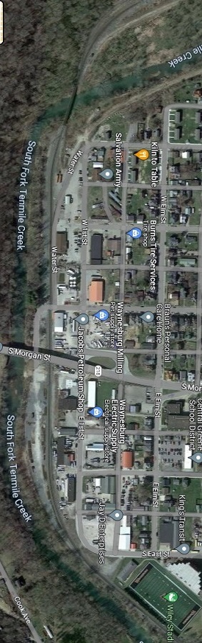
Now, if you look at the layout version of reality above, and think of the oval like a clock, the curve around the town runs from about 8 o’clock past lineside industrial trackage, through a sharp turn and past the interlocking tower (say, 2 o’clock). That’s the area of my town. The power plant is lower left, the coal mine is lower right.
The picture to the right shows reality (north is to the right). Here, you can see the tracks running under the Morgan St Bridge (off to the left). From the picture you can see evidence of old sidings here and there, and some of the buildings might have been served by rail back in the day (1962). But like the layout, the line bends sharply around the town, running towards a coal mine only a mile or so away (off the top of the picture). I got it pretty much right without even trying.
But that’s what this trip is about – I’ll spend a day looping east from Columbus to cross the state line and check this out. I expect to park somewhere near the Morgan Street Bridge, walk out onto it, and snap a couple of photos. I want to get the sense of the place (even though the layout track is down and scenery rapidly progressing).
This isn’t the first time. I wrote a novel about Carthage in the era before Google Maps was available. I actually went to the library to research the bay, the destroyed city, the hill overlooking the town. Five years later I got to stand on that hill, smile into the African sun, and realize I captured it pretty well.
Let’s hope, for my sake, my Pennsylvania looks a lot like actual Pennsylvania. It’s too far along to scrap at this point.
>>>AND IF YOU WANT TO NOSE THROUGH THAT BOOK I MENTIONED, ITS RIGHT DOWN THIS LINK<<<